The Met Office has issued a weather warning for New Year’s Day, with snow set to hit the UK as 2026 begins.
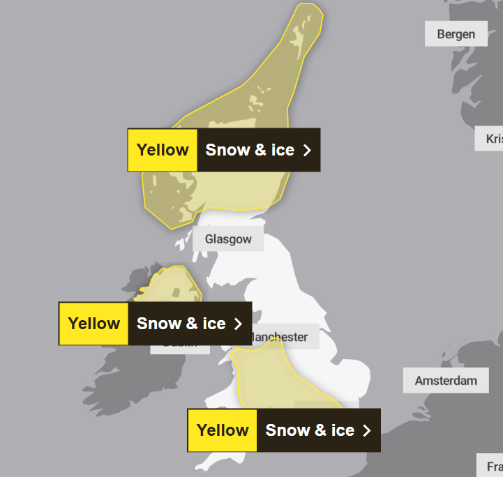
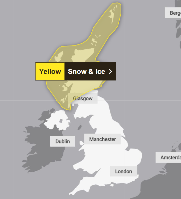
The yellow warning for snow and ice will be in force from 6am on Thursday, 1 January to 11.59pm on Friday, 2 January, covering northern parts of Scotland.
The weather agency warns that frequent and heavy snow showers in that area may lead to travel disruption, with up to 30cm of snow possible on the highest routes and hills.
On Friday, a yellow warning for snow and ice is in place from midnight until noon and covers a large swathe of England and Wales, including Chester and Greater Manchester down to London and Kent.
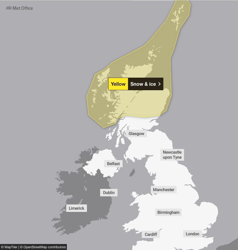
Meanwhile, residents in northern Scotland, with Central, Tayside and Fife, Grampian, Highlands and Eilean Siar, Orkney and Shetland, and Strathclyde can expect to see snow and icy conditions to welcome in the new year on Thursday morning.
About the weather in the areas covered by the warning, the Met Office said: “Showers will turn increasingly to snow through Thursday as a strong, perhaps locally gale force northerly wind sets in.
“Initially accumulations will mainly affect higher routes, but by evening some accumulations will start to build even to low levels, with 2 to 5, locally 10cm of lying snow accumulating by Friday morning.
“Above 200m some places could see 10-20cm of snow accumulate, and on the highest routes and hills, 30 cm or more may build through this period. Given the strength of the wind some significant drifting of snow is likely.”
Met Office deputy chief forecaster Mark Sidaway added: “It certainly looks like we are in for a taste of ‘winter’ as we welcome in the New Year, initially in the north, but more widely across the UK for the first week of 2026.
“Arctic air and strong northerly winds will bring cold or very cold conditions to all parts of the UK, and it will feel especially cold in the strong winds. Widespread and locally severe frosts are expected, along with the first snow of the winter for many.
“A yellow warning for snow and ice has been issued for northern Scotland on New Year’s Day and beyond, where frequent and heavy snow showers may lead to some travel disruption.
“These colder conditions and wintry hazards – snow, ice and strong winds – will develop more widely as we enter the New Year, with more warnings for snow and ice likely. It looks like this cold spell will last through at least the first week of January, so it’s important people keep up to date with the latest forecast and warnings.”
The UK Health Security Agency (UKHSA) has also issued an amber cold health alert for the health sector covering the north east and north west of England until 5 January. All other regions in England will be under a yellow alert for this period.
Dr Agostinho Sousa, head of extreme events and health Protection at UKHSA, said: “As the colder weather sets in it is vital to check in on friends, family and neighbours that are most vulnerable.
“The forecasted temperatures can have a serious impact on the health of some people, leading to increased risk of heart attacks, strokes and chest infections, particularly for individuals over the age of 65 and those with pre-existing health conditions.”
The UKHSA warned there will likely be an increase in demand for health services across the regions. With even younger people potentially impacted by the weather, it said that a drop in temperature leads to more risks for vulnerable people, while a fall in places like hospitals and care homes could bring it below the levels recommended for assessing health risks.
It also warned of staffing issues due to external factors such as travel delays, and said other sectors, such as transport and energy, could start to be affected by the weather.
Met Office forecast for the UK from Tuesday 30 December
Tuesday
Most places dry today with patchy cloud and sunny spells. A few showers are possible in southwest England and eastern coastal counties. Turning breezy in northern Scotland later with thicker cloud and outbreaks of drizzle.
Tuesday night
Cloudy in northern Scotland with patchy rain. Clear skies and light winds elsewhere will allow temperatures to quickly fall away with a widespread frost and a few freezing fog patches.
Wednesday
Dry across England and Wales with sunny spells. Cloudier in Northern Ireland and Scotland with scattered showers and strengthening winds.
Outlook for Thursday to Saturday
Turning very cold over the coming days. Snow showers will be frequent in Scotland, and gradually spread further south through the week. Sunny for many. Severe frosts and ice overnight.
