Hurricane Erin is spinning its way across the Atlantic toward the U.S. East Coast, but it still appears it’s going to swing north and miss a landfall in the lower 48.
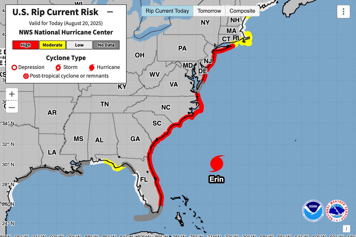
Even if the storm doesn’t have a direct hit on the East Coast, people living in those areas will still feel the storm’s presence in the form of dangerous surf and potential rainstorms.
The National Hurricane Center issued an advisory on Wednesday that places Erin approximately 455 miles south-southeast of Cape Hatteras, North Carolina. Its current maximum sustained wind speed is near 100 miles per hour with gusts higher than that, which makes Erin a Category 2 hurricane.
Forecasters at the NHC believe that the hurricane — the first major hurricane of the 2025 hurricane season — will strengthen before its power tapers off late in the week. Hurricane Erin will likely still have enough force to be considered a hurricane through the weekend.
The hurricane is expected to continue west toward the U.S. East Coast, traveling between Bermuda and North Carolina’s Outer Banks between Wednesday and early Friday. After that, the storm will continue north, passing south of Canada’s Atlantic coast on Friday and Saturday.
The NHC said in its advisory that Erin is still growing, and that its hurricane-force winds will extend up to 90 miles from its center. Tropical storm-force winds will extend up to 265 miles from its center.
Erin will produce swells that will affect Bermuda, the U.S. East Coast, Atlantic Canada, and the Bahamas during its journey up the edge of North America. Rough ocean conditions and dangerous rip currents will be likely along virtually all of the North American East Coast from Florida northward.
The National Weather Service has issued tropical storm warnings for eastern North Carolina from Beaufort Inlet to Chincoteague, Virginia. The warnings include Pamlico and Albemarle Sounds in North Carolina. Storm surges are expected from the Outer Banks to Duck, where the NWS predicts storm surges could reach between 2 to 4 feet.
The warnings predict that tropical storm conditions and potential surge flooding could occur in the affected regions during the next 48 hours.
Local officials in the Outer Banks warned that Highway 12 — the only road connecting the Outer Banks to mainland North Carolina — could be flooded, cutting off the island until the swells recede. That has sent some residents and vacationers evacuating from the Outer Banks ahead of the storm’s approach, according to USA TODAY. Dare County officials — who represent part of the Outer Banks — ordered evacuations on Monday.
As the hurricane passes by Cape Hatteras, North Carolina, the NWS predicts it could generate waves between 8 and 20 feet. Those waves could contribute to coastal flooding and erosion in the region.
Residents in parts of Florida — like Ponce Inlet — were subjected to large waves generated by Hurricane Erin early on Wednesday morning. On Monday, thousands in Puerto Rico were left without power due to the storm.
Bermuda is also under a tropical storm watch for the next 48 hours as the storm passes between the island and the continental U.S.
Thankfully, the NWS said that Erin’s strongest winds shouldn’t come anywhere near the continental U.S.
Erin began as a cluster of storms off the northwest coast of Africa before they spun into a tropical storm and then a hurricane. The storm is notable for reaching major hurricane status — given to any storms that reach Category 3 or higher — this early in hurricane season.
According to the NHC, major hurricanes tend to form in the middle of hurricane season, usually in September through mid-October.
